


florac 19km /500+

Patriste
User
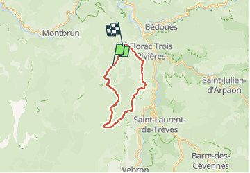

Length
21 km

Max alt
1244 m

Uphill gradient
533 m
Km-Effort
28 km

Min alt
976 m

Downhill gradient
500 m
Boucle
No
Creation date :
2025-05-25 07:53:32.355
Updated on :
2025-05-25 15:01:03.25
7h06
Difficulty : Medium

FREE GPS app for hiking
 SityTrail
IGN / Geographical institutes
SityTrail Plus
The world is yours!
About
Trail Walking of 21 km to be discovered at Occitania, Lozère, Florac Trois Rivières. This trail is proposed by Patriste.
Positioning
Country:
France
Region :
Occitania
Department/Province :
Lozère
Municipality :
Florac Trois Rivières
Location:
Florac
Start:(Dec)
Start:(UTM)
544337 ; 4906799 (31T) N.
Comments